I left Yankton and the slightly odd Broadway Inn with the faintest pangs of homesickness. A combination of the football and hearing Duffy’s ‘Warwick Avenue‘ playing in Quizno’s subs the night before (incongruously) were to blame. (For those who don’t know, Warwick Avenue is an underground station just a hop, skip and a jump from where I live in NW London).
It had rained heavily again overnight and there was substantial surface water on many of the main roads. My route to Niobrara State Park (back in Nebraska again – I couldn’t seem to quite leave the cornhusker state) took me remarkably close to some rivers in spate. There was water water everywhere but – as Lewis & Clark’s men found out – drinking out of the Big Muddy isn’t a great idea. The clue is in the name. It’s not so bad since the dams helped prevent the flow of sediment that gave the river its nickname.
I decided against the back-road option after a careful look at the map suggested that these were likely to be impassable. Even the cattle I could see in pens were either wedged into the driest corner or perched on small mounds to avoid being knee-deep in mud. This of course was precisely what the Corps of Discovery was used to as they hauled the boats upriver.
Today, their path would abruptly halted by not one, but six of these dams. The first one – Gavins Point – we’ve already seen. Today’s journey to Pierre would see me cross two more. The first one was Fort Randall Dam at Pickstown. That should really be Pickstown at Fort Randall Dam as the town was built solely to service the building of the dam. The dams were part river management and hydroelectric program and part mass employment program, but all those workers needed homes to live in, schools for their children and shops in which to spend their hard-earned dollars. Thus towns such as Pickstown came into being.
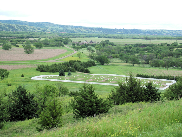
Fort Randall Dam is run by the US Army Corps of Engineers, an illustrious arm of the US military that more or less seems to reckon that it can build anything anywhere, and has been proven right on many occasions. The dam was named after the Fort Randall Military Post built in 1856 – one of the peacekeeping posts on what was the western frontier. It survived until 1892 but today only the cemetery and part of the chapel remain.
The two girls manning the Fort today – or at least the visitor centre – seemed delighted to have some visitors. They eagerly looked up road closure information for me and one of them told me how beautiful she had found London on a visit a couple of years ago. “In a different way,” she added.
Certainly the scenery was changing. I had said my final goodbye to Nebraska. For the next few days I was in the Dakotas and already the landscape was opening up. It was a bit like parts of the North Yorkshire Moors – maybe greener, and definitely bigger. Much much bigger. My guidebook was on a new section: The Great Plains. But I hadn’t quite crossed the Hundredth Meridian, where – as all fans of Canadian pop icons The Tragically Hip will know – is where the Great Plains begin.
From Fort Randall, a Scenic Byway heads a series of perpendicular jags north and east until it hits I-90 and the town of Chamberlain. Having largely avoided busy interstates for a few days, it was a relief to find this major corridor also quiet on a rainy Sunday. Sad though that the roadside was littered with enormous hoardings enticing weary travellers to Al’s Oasis or (more realistically one felt) to various national fast food franchises.
Some, like me, pulled off at the new visitor centre, which houses a Lewis & Clark exhibition. After managing to park in a slot reserved for the Highway Patrol (bad idea), I finally made my way in. There was nothing new for the hardened L&C fan except another replica of the keelboat slung up as a sort of mezzanine level, and projecting out of the building. And some nice views. There were South Dakota tourist office people on hand but they seemed to be occupied with questions about the state’s two major attractions, Mt Rushmore and the Black Hills, both off to the west.
The Corps camped near here for several days – the site is believed now to be submerged beneath the lake created by the dam. They too had endured persistent drizzle and rain and needed a break. The river was becoming shallower and the sandbars and snags (trees branches wedged in the river bed) were making progress even slower than it had been. On the upside, food was plentiful. Alongside the infinite numbers of buffalo were rabbits, the ubiquitous prairie dogs and pronghorn (commonly although mistakenly referred to as an antelope).
Chamberlain looked like a nice town – its advantageous position as a river crossing had clearly brought a degree of prosperity. I was heading north to Big Bend Dam at Fort Thompson. The Corps had lightened the load of the keelboat and sped up considerably over the next stretch, averaging more than 18 miles a day. I was averaging considerably faster than that, but declined the opportunity to visit Fort Thompson itself, which is now an incredibly poor Indian reservation community.
Instead, I drove across the dam and headed for the Big Bend itself. This remarkable bit of fluvial landscape still stands out on maps of the area. The river loops right round a small promontory of land some 2,000 yards across, but (according to Lewis’s estimate) 30 miles by water.
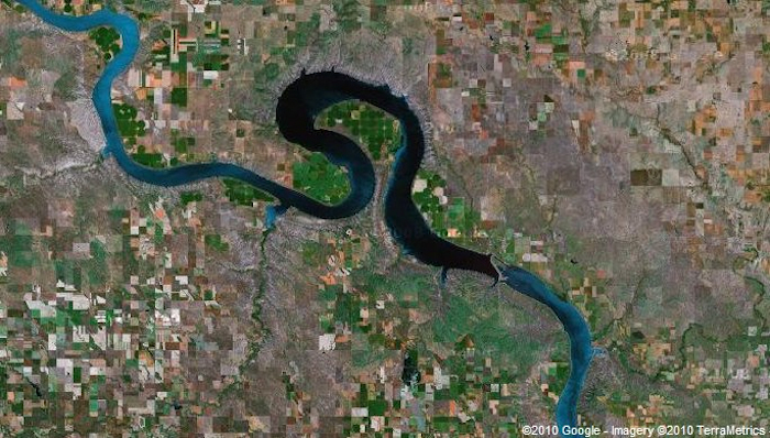
The Narrows, as this bit of land is called, is owned by the Lower Brule Indian Reservation and I’d picked up literature saying that there was a car park and a few interpretive signposts on the promontory and that it might even be possible to walk up the small hill to get a view of the bend itself.
Driving through Lower Brule, another poor looking community with the obligatory casino, things weren’t looking too promising – no signposts suggesting a tourist attraction. In the days when steamboats plied these waters it was seen as something of a novelty for passengers to disembark, and stroll across to the other side and wait for the boat to pick them up again.
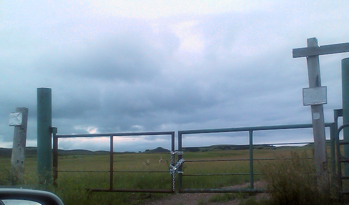
I found the car park. There were none of the Lewis & Clark information boards and the gate that clearly led to the path was well and truly locked. A real shame.
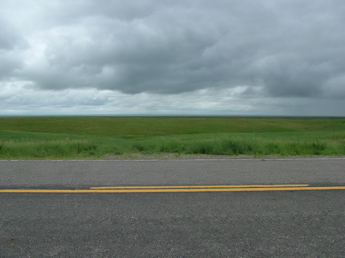
My disappointment was tempered by the scenery on the final leg of the drive from here to Pierre, the state capital. Taking the scenic route was really paying off – I had now crossed the Hundredth Meridian, clocked up a thousand miles since leaving St Louis, and the Great Plains were spread before me.
The scale of the landscape was too hard for me to capture on camera, especially in the drizzle and with no access to land away from the road. How I wished for Scottish-style open access so I could tramp up to one of the many knolls and drink in the magnitude of the dips and bumps. It was hard to imagine these grasslands covered in wildlife as they were when Lewis & Clark passed through. Today there were birds aplenty and some cattle, but nothing else that I could see.
I did see two creatures that might have been bison, but it was too hard to tell from where I was – they are farmed in this area, so it’s more than possible. In fact, I’d hoped to pay a visit to the Lower Brule Buffalo Interpretive Center, but sadly it’s open only on weekdays. Far be it from me to suggest that maximizing tourist revenue means opening things on weekends, when tourists tend to be around. (By the way – buffalo and bison are more or less interchangeable in these parts. Technically, the animal is a bison, but people still commonly refer to them as buffalo.)
And so, over the river and into Pierre, site of the stand-off with the Teton Sioux – a far more belligerent people than their Yankton brethren, but also of critical importance to the expedition’s success.